
Docker-OSM
A docker compose project to setup an OSM PostGIS database with automatic updates from OSM periodically. The only files you need is a PBF file, geojson (if you intend to restrict data download to a smaller extent than the one specified by the PBF) and run the docker compose project.
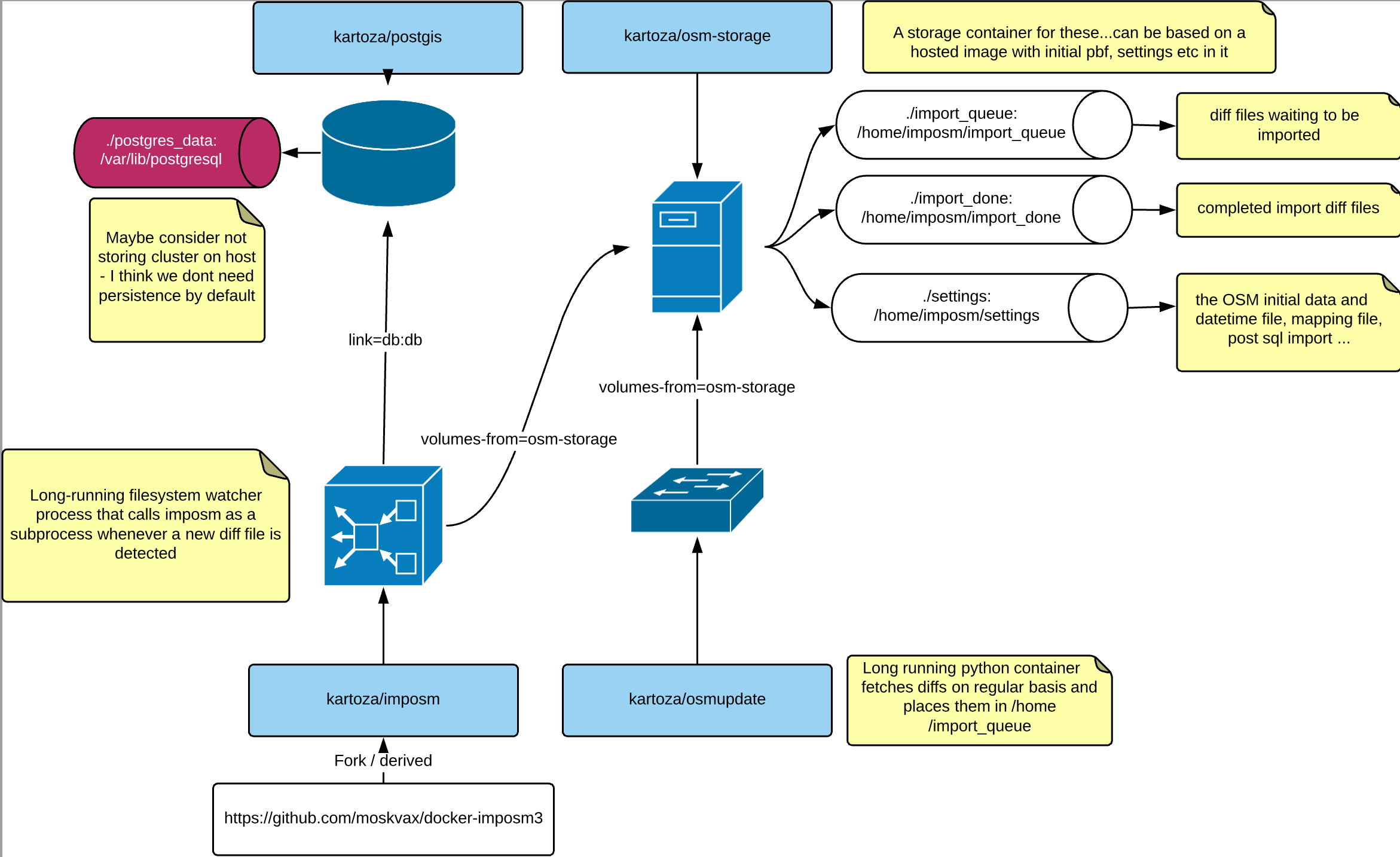
General architecture

Quick setup
As a quick example, we are going to setup Docker-OSM with default values everywhere:
- Download a PBF file from http://download.geofabrik.de/
- Put the file in the
settingsfolder and rename itcountry.pbf.
Alternatively you can execute the settings_downloader.sh script to download the pbf and the clip file
bash ./settings_downloader.sh GEOJSON_URL CONTINENT COUNTRY ie
bash ./settings_downloader.sh https://github.com/kartoza/docker-osm/raw/develop/settings/clip.geojson africa south-africa
For a full list of allowed file names read json file countries.json
Alternatively you can use the python script pbf_downloader.py
For local usage, the containers are set up using docker-compose configuration. The configuration files consists of
two sets of config file. The first one is .env which contains lists of environment variables.
Copy the .env file from the .example.env in this repo.
cp .example.env .envFor subsequent configuration, edit the .env files to tweak your options.
The second set of configuration is using a docker-compose.yml files, which is a compose files docker-compose is using.
For minimum set of production environment, the configuration file is described in docker-compose.yml file.
The other YAML files with prefix docker-compose is a configuration file that you can merge with the basic docker-compose.yml file. To use more than one configuration file, you edit .env file and change the COMPOSE_FILE variable to include all
the compose file you desired, separated by a colon : for each file.
For example, by default, the example file is using both docker-compose.yml and docker-compose.develop.yml because
we expect you to provide the necessary settings in settings folder. Thus the COMPOSE_FILE variable looks like this:
COMPOSE_FILE=docker-compose.yml:docker-compose.develop.yml
In production environment, normally all the persistent data is stored in a volume, instead of bind mounted.
In this case only the docker-compose.yml is enough, and you need to provide the settings inside the volume itself.
To build the image yourself, include the docker-compose.build.yml file.
To use helper services such as pgadmin, include docker-compose.pgadmin.yml, and docker-compose.web.yml for web demo.
If you are familiar with how docker-compose work, you can also use a standard convention by putting docker-compose.override.yml
file and include it in the COMPOSE_FILE variable.
To store the configuration for long-term use (for archiving or diffing of different configuration). You can interpolate the
current variables in .env and generate a full config files:
docker-compose config > docker-compose.production.ymlThe above command will include and merged all your config files specified in COMPOSE_FILE variable and also fill out the
variables parameterized in the docker-compose file.
- If you want to connect from your local QGIS Desktop:
- In the file
docker-compose.yml, uncomment the block:
- In the file
# Uncomment to use the postgis database from outside the docker network
ports:
- "35432:5432"- Do
make runin the build directory. This will download and execute the docker-osm project. It might be very long depending of your bandwidth and the PBF you are importing. - In QGIS, add a new PostGIS connection:
localhost, databasegis, port35432,dockerfor both username and password. - That's it! You have an OSM database, up and running. The update is done every 2 minutes from the main OSM website.
For further reading and customizations, read below.
Docker cloud
Dockerfiles are executed on Docker Cloud kartoza/docker-osm
docker pull kartoza/docker-osm:imposm-latest
docker pull kartoza/docker-osm:osmupdate-latest
To run you can use the provided docker-compose project and use the images hosted on the internet. This is useful if you want to integrate Docker-OSM in your existing docker-compose project.
Usage
PBF File
In this example we will set up an OSM database for South Africa that will pull for updates every 2 minutes.
Specify a PBF file for your area in the environment variables for osm_downloader container.
You can download some PBF files on these URLS for instance :
You must put only one PBF file in the settings folder. Only the last one will be read.
OSM Features
In settings, you can edit the mapping.yml to customize the PostGIS schema.
You can find the documentation about the mapping configuration on the imposm
website: https://imposm.org/docs/imposm3/latest/mapping.html
The default file in Docker-OSM is coming from
https://raw.githubusercontent.com/omniscale/imposm3/master/example-mapping.yml
Note Imposm is designed for spatial analysis, not for OSM contribution analysis. If you need such a feature, you need to use another database schema supporting OSM Metadata. You can check the OSM Wiki for "Lossless" schemas.
Updates
You can configure the time interval in the docker-compose file. By default, it's two minutes. If you set the TIME variable to 0, no diff files will be imported.
The default update stream is worldwide. So even if you imported a local PBF, if you don't set a clipping area, you will end with data from all over the world.
Clipping
During the initial import or post update imposm uses the flag -limito which allows
you to define a smaller area that you can work with.
This is always desirable to limit the features being imported into the database rather
than clipping them.
NB: Ensure you add a geojson covering the area you intend to clip into the settings folder.
The geojson can be the same extent of the administrative area for your country, or it can be a
smaller extent. The CRS of the geojson should always be EPSG:4326.
NB: It is encouraged to simplify the geometry for the clip.geojson as
a simplified geometry is easier to process during the import.
Rather use the minimum bounding box for the area you intend to clip your dataset with.
QGIS project
There is a default QGIS project provided in the web/ folder, named osm_mirror_qgis_project.qgz. To be able to load the layers in this project correctly in QGIS, first run make materialized_views and make elevation then set up your connection service file with the following parameters. The host parameter is where you have set up docker-osm:
[docker-osm]
dbname=gis
port=35432
user=docker
password=docker
host=<host>
sslmode=disable
QGIS Styles
The database is provided with some default styles. These styles will be loaded automatically when loaded in QGIS. It's following the default OSM mapping from ImpOSM.
make import_styles
make remove_styles
make backup_styles
SQL Trigger, functions, views...
You can add PostGIS functions, triggers, materialized views into an SQL file called post-pbf-import.sql.
It will be imported automatically in the database.
Build and run
Now build the docker images needed to run the application:
docker-compose build
docker-compose up
In production, you should daemonize the services when bringing them up:
docker-compose up -dYou can check the timestamp of your database by reading the file :
settings/timestamp.txt or you can use :
make timestampDisplay
In the makefile, you can switch to another docker compose project.
The other one includes QGIS Server. When it's running, you should be able to
open, on the host(not in docker), the index.html file and see OSM and QGIS
Server showing PostGIS tables. The webpage is using Leaflet.
If you want to tweak the QGIS Project, you need to add a host in your in /etc/hosts:
127.0.0.1 db
Because in the docker-compose file, the link is made with the PostGIS database using the alias db.
In the background
Docker OSM Update
This docker image, when run will regularly fetch any new diff file for all the changes that have happened in the world over the update interval.
You can also specify a custom url for fetching the diff if you wish to retrieve regional diffs rather than the global one.
You can specify a polygonal area for the diff so that it will only apply features from the diff that fall within that area. For example providing a polygon of the borders of Malawi will result in only Malawi features being extracted from the diff.
Note: the diff retrieved and options specified here are not related to the initial base map used - so for example if your initial base map is for Malawi and you specify a diff area in Botswana, updated features in Botswana will be applied to your base map which only includes features from Malawi. For this reason, take care to ensure that your diff area coincides with the region covered by your original base map.
Once the diff has been downloaded, it is placed into /home/import_queue where it will be picked up by the long running imposm3 container, which will apply the diff to the database.
You should have 3 folders : osm_pbf, import_queue, import_done
Put a state file in base-pbf like this one : http://download.openstreetmap.fr/extracts/africa/south_africa.state.txt
docker build -t osmupdate .
docker run -v $('pwd')import-queue/:/home/import-queue -v $('pwd')base-pbf/:/home/base-pbf -v $('pwd')import-done/:/home/import-done -d osmupdate
With -e, you can add some settings :
 - MAX_DAYS = 100, the maximum time range to assemble a cumulated changefile.
 - DIFF = sporadic, osmupdate uses a combination of minutely, hourly and daily changefiles. This value can be minute, hour, day or sporadic.
 - MAX_MERGE = 7, argument to determine the maximum number of parallely processed changefiles.
 - COMPRESSION_LEVEL = 1, define level for gzip compression. values between 1 (low compression but fast) and 9 (high compression but slow)
 - BASE_URL = http://planet.openstreetmap.org/replication/, change the URL to use a custom URL to fetch regional file updates.
 - IMPORT_QUEUE = import_queue
 - IMPORT_DONE = import_done
 - OSM_PBF = osm_pbf
 - TIME = 120, seconds between two executions of the script
If you are using docker-compose, you can use these settings within the
docker-compose.yml file.
Docker ImpOSM3
This image will take care of doing the initial load for the selected region (e.g. planet, or a country such as Malawi) into your database. It will then apply, at a regular interval (default is 2 minutes), any diff that arrives in the /home/import_queue folder to the postgis OSM database. The diffs are fetched by a separate container (see osm_update container).
The container will look for an OSM file (.pbf) and its state file (.state.txt) in BASE_PBF.
With -e, you can add some settings :
 - TIME = 120, seconds between 2 executions of the script
 - POSTGRES_USER = docker, default user
 - POSTGRES_PASS = docker, default password
 - POSTGRES_HOST = db
 - POSTGRES_PORT = 5432
 - SETTINGS = settings, folder for settings (with *.json and *.sql)
 - CACHE = cache, folder for caching
 - BASE_PBF = base_pbf, folder the OSM file
 - IMPORT_DONE = import_done, folder for diff which has been imported
 - IMPORT_QUEUE = import_queue, folder for diff which hasn't been imported yet
 - SRID = 4326, it can be 3857
 - OPTIMIZE = false, check (Imposm)[http://imposm.org/docs/imposm3/latest/tutorial.html#optimize]
 - DBSCHEMA_PRODUCTION = public, check (Imposm)[http://imposm.org/docs/imposm3/latest/tutorial.html#deploy-production-tables]
 - DBSCHEMA_IMPORT = import, check (Imposm)[http://imposm.org/docs/imposm3/latest/tutorial.html#deploy-production-tables]
 - DBSCHEMA_BACKUP = backup, check (Imposm)[http://imposm.org/docs/imposm3/latest/tutorial.html#deploy-production-tables]
You can adjust these preferences in the docker-compose.yml file provided
in this repository.
PostGIS
For environment variables associated with docker-postgis refer to docker postgis repository
Support
If you require more substantial assistance from kartoza (because our work and interaction on docker-osm is pro bono), please consider taking out a Support Level Agreeement
Credits
This application was designed and implemented by:
- Etienne Trimaille ([email protected])
- Tim Sutton ([email protected])
With some important design ideas provided by Ariel Nunez ([email protected]).
Parts of this project are built on the existing work of others.
July 2015